Wednesday, June 30, 2010

Detachment Quotes

Savahia Peak in the Whipple Mountains, CA.
Here are a few detachment quotes, including the one from my blog header. The last two are paraphrased from long ago. I've posted some of these quotes on my Quotes page, under "A few quotes about detachment." (I have pages now!)
...reality can be attained only by someone who is detached.
Simone Weil
An old thing becomes new if you detach it from what usually surrounds it.
Robert Bresson
The detached observer's view is one window on the world.
Kenneth L. Pike
To be consistently effective, you must put a certain distance between yourself and what happens to you on the golf course [or in the field]. This is not indifference, it's detachment.
Sam Snead
Every scene, even the commonest, is wonderful, if only one can detach oneself, casting off all memory of use and custom and behold it, as it were, for the first time.
Arnold Bennett
I have, I admit, a low tolerance for detached chronicling and cool analysis.
Leslie Fiedler
I live in a bus and go from place to place and sometimes feel very detached from what's going on.
Gavin DeGraw
When he has the power to see things detached from self-interest and from the insistent claims of the lust of the senses, then alone can he have the true vision of the beauty that is everywhere. Then only can he see that what is unpleasant to us is not necessarily unbeautiful, but has its beauty in truth.
Rabindranath Tagore
Are you feeling detached yet?
One geologist to another while standing
at the base of the Whipple Mountains.
Is it detachment or ennui?
One geologist to another on a particularly long stretch of road

Monday, June 28, 2010

Enargite from Goldfield

I've got a couple final mineral pictures from Goldfield, NV. The first two are of enargite and pyrite in a quartz matrix, with a fair amount of iron-oxide and possible jarosite.
Enargite is metallic, often dark gray, and it's orthorhombic — although the crystal form doesn't show well in these examples, and instead the enargite masses look almost globular. A key feature with these enargite specimens are tiny little pyrite crystals, the pyrite being in a bipyramidal (octahedral) form. Our field trip guide said that the occurrence of bipyramidal pyrite at Goldfield was often related to enargite, and that when one sees bipyramidal pyrite, one should start looking for enargite and other ore-related minerals (and gold).
Here's another example of what the enargite looks like, this time without much (or any) pyrite.
Enargite is a copper arsenic sulfosalt sometimes found at porphyry copper districts and at high-sulfidation epithermal gold districts like Goldfield (also see this report on a high-sulfidation system in Mexico).

High-sulfidation epithermal gold deposits used to be called quartz-alunite deposits, because of their dominant alteration minerals. "High sulfidation," which is really an adjective but is sometimes used as a noun, isn't something you can necessarily see in the field (it doesn't always indicate the existence of a high percentage of sulfide minerals, though abundant sulfides are common in high-sulfidation systems), so I prefer the old term, quartz-alunite. That preference definitely dates me as an oldtimer.

The opposite of quartz-alunite is, generally speaking, quartz-adularia (or quartz-sericite); the opposite of high-sulfidation epithermal is low-sulfidation epithermal. The former classification system is based on descriptive field terms; the latter is ultimately chemical or geochemical.

Sunday, June 27, 2010

First Cactus of the Summer


  The first cactus of summer:                                                      
  a prickly pear.


Seen recently while up looking at the lower of three-in-a-row old mine entrances.

One & Two Years Ago Today: Trips to the Ovens

sign1sign2
Signs: Nevada Historic Marker #184 and Mining Charcoal
(Click to enlarge)

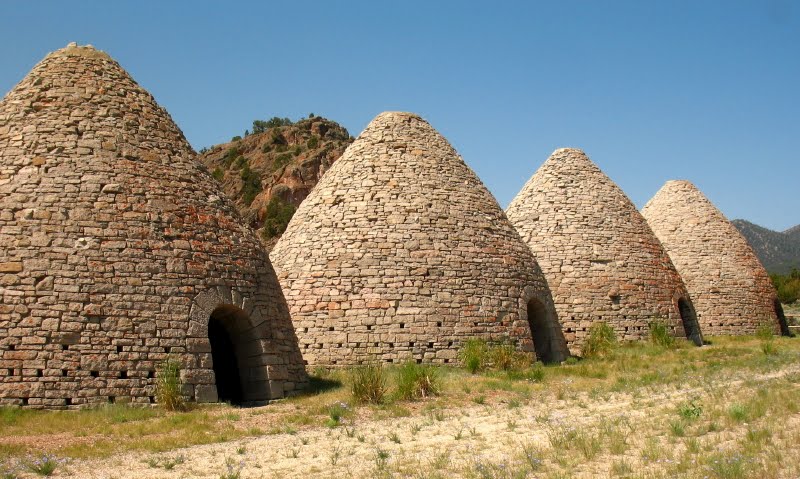
One year ago today, while some family types were visiting, we all packed up and drove to the Ward Charcoal Ovens, which are inside the Ward Charcoal Ovens State Historic Park, and aren't far off Highway 50 on a good, sometimes washboarded, graded dirt road.
The ovens, built in 1876 out of blocks of nearby quartz latite ash-flow tuff, are partially fenced, and it's difficult to get good pictures sans fencing. You can see some of the ash-flow tuff behind and between the two ovens. There are six ovens, here I'm only showing two. (More will be shown later.)
Looking closely at the first or easternmost oven, I spot something growing part way up the right side. What is it?
Maybe it's a weed?
Closer... It's a wildflower!
This is the kind of flower growing in between the blocks of the charcoal oven, a Penstemon, possibly this one.
The rest of our short visit became an excuse to take pictures of the penstemons, at least for me.
And more...
...and even more.

I've visited these ovens several times over the last three years, and have taken many pictures. In fact, one such visit was exactly two years ago today, when other family types were visiting. There must be something about June!
4 The lighting is usually a factor in the kinds of pictures one can take, and I'd say that morning and afternoon are probably best, rather than high noon. Fall before the snow flies might also be better than mid-summer, especially because the heat can seem hotter at the ovens than elsewhere in Steptoe Valley. Note another hill of ash-flow tuff behind the ovens; these hills are fun to hike.
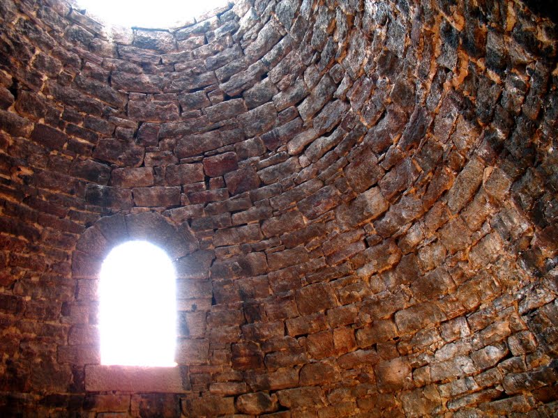
inside1 It's difficult to get photos inside the ovens without using a tripod, but here are two of my best shots.
inside2 Charcoal darkens the walls, and there's been a little oxidation over the years.

Saturday, June 26, 2010

Today's Hike: A Bird Sandwiched by Two Lizards

liz1Hiking up the hill today, I spied at least two lizards. The first lizard was located fairly low on the hill, maybe at about 6800 feet in elevation. I don't know my lizards well, so I can't tell you what name this guy goes by, but he (she?) has nice scales, a bit of a pattern hidden in all that gray, and a little brown near the shoulders and on the back.
flt1 Farther up the hill, I decided to do a little investigation of some old mine workings, and so I went inside this adit. What is a little hard to notice in the photo is the wren hanging out on the fault-plane side of the photo (that would be the left side).
flt2 It's probably a rock wren, like these younger ones we saw about a year ago lower on the hill. (The adit is at about 7000 feet.) This one bird was flitting around, in and out of the adit before I arrived on the scene, and after I walked into the mine to look around and take some pictures, it eventually came back, still darting here and there, hardly staying in one place long enough for me to shoot. My camera noise bothered it a little. I wondered if it had a nest somewhere, but it never settled down, and never flew at me protectively. (I don't know if wrens do that.)
salt1 It eventually flew into the mine behind me, where there were at least two main drifts going off to each side to connect with other underground workings and surface openings. The wren is hard to spot in the photo above; it blends in with the rock.
salt2 Even enlarged, the rock wren is hard to see, there in the upper right below a shadow. I think it may have been after the salt efflorescence on the rock surfaces, though perhaps there were small bugs in there. (I didn't notice any.)
post1 And here's the little wren again, this time just a small white spot above the mine timber on the adit sill (that's floor to you non-miners).
post2 Enlarged a bit, you can see more than just it's white chin.
lg1 This is the closest shot I managed to get. We're both still inside the mine, close to the entrance. I hardly moved while all this darting and flitting was going on around me, other than to turn to face in different directions.
liz2After awhile, I left the mine, leaving it for the rock wren claimant. On the mine dump, I spotted another lizard, maybe the same kind as before, maybe a different kind.

Friday, June 25, 2010

Finding a Thesis: Pole Line to Belmont

The next place on my continuing find-a-thesis journey was the silver mining district of Belmont.

Part of the Tonopah 1:250,000 sheet via MSRMaps courtesy USGS.

A little less than half way down the Pole Line Road to Tonopah, where the Shoshone Mountains nearly merge with the Toiyabe Range, I took one of several dirt roads that show up on the Tonopah 2° sheet as dashed, gray lines. I'm not sure which road I took, and as you can see from the map above, there are quite a few dashed-gray roads. In fact, even today there are more old roads than show on any old or new maps.

Looking down the Pole Line Road toward the Hall Moly Mine
in the San Antonio Mountains.


None of the trails or byways promised to allow me to easily skirt the many ups and downs on the alluvial fans coming out of the south end of the mountains — from Ione Wash and Cloverdale Creek on across to the drainages of Cottonwood and Peavine Creeks. Ultimately, if I could make it, I would have to traverse about 25 miles of alluvial fan to attain Highway 8A south of Round Mountain. These roads are now, for the most part, wider and smoother than they were in 1976, and most can be driven at 40 to 60 mph depending on your vehicle, the weather, and your overall driving inclination. I probably drove most of the way in my Opel at a quarter to half that speed.
By the way, the southern Shoshone Mountains and southern Toiyabe Range are made primarily of Tertiary volcanic rocks, including this vitrophyre above poorly to moderately welded ash-flow tuff and below a thick pile of moderately to strongly welded tuff.
The sun was low in the western sky when I left Pole Line Road, and as I made my way across the channeled fans and through scattered rocky zones, it seemed to sink rapidly. At the time, I had rarely driven on dirt, and I wondered constantly whether the road would get worse or come to some impasse. Even today, in a 4WD truck, this part of the road is not fast, requiring speeds of 15 to 30 mph. Could I have possibly gone that fast in my light blue sedan?

At least it's not an Opel!

The road seemed endless. I drove up and down and over and across incised dry washes, one after the other, on and on. I saw a couple other vehicles now and then — on other roads — and I saw a ranch or two in the distance. I felt conspicuous and out of place. I worried that I might get stuck in the sagebrush and soft dirt on the side of the road if I tried to turn around — and the way south on Pole Line to Tonopah and then back north on Highway 8A would be appreciably longer — so I kept going. I kept going as the light turned orangey yellow, not knowing for sure if I was really on the right road, or if the road would go through, deteriorate, or disappear altogether.

The good road as it heads west toward San Antone Ranch.

At some point, a better road came in from the south, maybe near San Antone Ranch, which, as it turned out, was only 9 miles from pavement. Had there been a better and more direct route all along?

Southern Toiyabe Range volcanic rocks and Peavine Ranch.

Through the entire Ione Wash to Big Smoky Valley crossing, I saw several ranches, some distant, some near. The ranch at the mouth of Peavine Creek is appropriately known as Peavine Ranch; it comes into view as one nears the pavement at old Highway 8A.

Highway 8A looking north near the Manhattan turnoff.

Finally, I made it across the valley to pavement at Highway 8A, I turned north, then east onto Highway 69, the Manhattan Road (now S.R. 377). I drove into the small town of Manhattan near dusk, then east over a low pass, and then north to Belmont on the east side of the Toquima Range.

It was too dark to do much at Belmont, so I drove north on the wide, bladed, Monitor Valley Road (AKA Old Belmont Road, previously old Highway 82, now unnumbered). I found a tiny place to pull off and set up a little camp behind my car. I didn’t really like sleeping so close to a main road, but my car gave me zero access to any other site, and it was dark, past time to stop. I ate what I had, wrapped my space blanket around my newly bought (though old), army-issue, goose-feather sleeping bag and settled down on the dirt behind my car for the night. The bag was sold to me as a down bag, good to 20°F. Ha! Nowhere near!

Now why didn't I stop at this bar?

I awoke the next morning covered by a dusting of snow, my bag and clothes wet, inside and out. While chomping on a granola bar or two, I drove on dirt to the old workings. By means of the early morning light, I looked around some of the mine dumps south of the old Combination Mill (zoom out to see what I mean about 1:100,000 topos showing very few old workings). I remember seeing lots of quartz vein material, quartz lying around everywhere. Hmm... interesting area!

Combination Mill ruins.

One thing I didn't realize at the time, was that had I gotten a tour of the old courthouse in Belmont, the former county seat of Nye County, I would have seen this piece of graffiti, purportedly left by C.Manson and family in 1969, seven years prior to my arrival on the scene. More importantly though, the Belmont Courthouse and other remaining structures are worth traveling across Nevada to see, so put the place on your list!

[Don't confuse the town of Belmont in Nye County with the Belmont Mill in White Pine County, which is also worth seeing.]

Old building at Belmont.

I had the feeling that the area was too crowded, with the main dirt road going by, with the small community of Belmont just over the hill, and with the town of Manhattan just over the mountain. It would ultimately take me quite some time to feel comfortable working in the field if there were many people around, and even now, I prefer uncrowded, back areas: the middle of so-called nowhere.

I finished up looking around the old dumps, headed back over the pass, coasted downhill through Manhattan and back to Highway 8A, and then I turned left, to cruise south toward Route 6. My route would take me through Tonopah, past the Divide district, into the Palmetto Mountains, and on to Silver Peak.

To be continued someday...

Thursday, June 24, 2010

Barite from Goldfield

Continuing down the pallet at Goldfield, NV, I spotted this huge rock made almost entirely of barite.
This is hydrothermal barite, not the bedded barite often mined for barite drilling mud (with Nevada being the largest producer in the U.S., and third after China and India worldwide in 2008).
Here's a closeup photo showing nice orthorhombic barite crystals coated with tiny druses (quartz?). Barite is often first noticed because of its high specific gravity – it's very heavy compared to other minerals and hand samples – and it doesn't fizz in HCl the way calcite and limestone do.

I've got some nice barite crystals from the Northumberland gold mine, tucked away in a box somewhere. The particular small pit my crystals came from has long since been mined.

More About Barite:
Jewell, P. W., 2000, Bedded barite in the geologic record: SEPM Special Publication, v. 66, p. 147-161 [link to abstract].

Jewell, P. W., and Stallard, R. F., 1991, Geochemistry and Paleoceanographic Setting of Central Nevada Bedded Barites: Journal of Geology, v. 99, p. 151-170 [link to abstract].

Nevada—2007: USGS Minerals Yearbook, Volume II, Area Reports: Domestic.

Rossi Mine - Barite, Elko County, Nevada – with photos of bedded and crystalline barite.

Goldfield series so far:
Headframes of Goldfield
Alunite from Goldfield
Pyrophyllite from Goldfield
Barite from Goldfield (this post)
Enargite from Goldfield

Monday, June 21, 2010

Pyrophyllite from Goldfield

And we've got another mineral from Goldfield, NV, this time pyrophyllite, a monoclinic phyllosilicate (sometimes also reported with a triclinic form). Although often a metamorphic mineral, at Goldfield it's a hydrothermal alteration mineral. Hard to say what the original rock was, and I don't see any remanent quartz eyes or textures.
Pyrophyllite can be a relatively nondescript clay-like or sericite-like mineral: white, with crystals too small to see. Compared to alunite, the feel of this pyrophyllite-rich rock was talc-like to greasy, and the sheen was pearly. I didn't try the stick-tongue method of checking for kaolinite; I presume it would fail but don't know for sure.
Although crystals of pyrophyllite are more commonly seen forming radiating clusters, these crystals show a somewhat tabular form (if enlarged, this photo will be larger than the previous one). In hydrothermal areas, pyrophyllite is often mistaken for sericite, a very fine-grained white mica. If you can find masses large enough for a scratch test, it's much softer (H = 1-2) than alunite (H = 3.5-4) and slightly softer than sericite (H = 2.5). It's often worth getting an x-ray diffraction or thin-section analysis for positive identification.

Sunday, June 20, 2010

Alunite from Goldfield

We saw a lot of rocks and minerals on last month's field trip to Goldfield, NV. At the second stop, our f.t. leader had laid out a large collection of large rocks on pallets, one row for one area, one row for another. The pallets were then arranged, north to south, by the age of the rocks. I thought it was a great way of arranging the rocks, especially since we didn't have time to go see them all in the field!
Today's mineral from Goldfield is alunite, a trigonal, sometimes psuedo-cubic, anhydrous alumino-potassic sulfate. In this photo, it's a hydrothermal, hypogene alteration mineral replacing potassium feldspar in rhyolite.
Goldfield has some of the nicest alunite I've seen, with a classic pink color, although one can also find classic pink alunite at Alunite, Utah and other places.
More alunite, still pinkish, and showing its classic tabular crystal form.
If you see a mineral with this shape, think alunite. It's not always pink (or reddish); it can be colorless, white, gray, to yellowish. The supergene form is often massive, looking somewhat like jarosite.